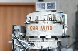
Biogeohab, a company from St. Petersburg, has developed the OpenSeaGeo system, designed for automated search of minerals and mapping of the seabed. The intelligent complex has already been tested on research vessels.
OpenSeaGeo combines marine geology, artificial intelligence, and computer vision technologies. The development allows for improved study of oceanic depths and the search for underwater resources.
The system is based on the YOLOv7 computer vision architecture, adapted to work in turbid water and low light conditions. It provides high accuracy and data processing speed—up to 60 frames per second on powerful graphics processors.
Artificial intelligence in OpenSeaGeo accelerates data analysis and reduces the likelihood of errors, increasing the reliability of scientific conclusions.
The hardware part of the complex includes a sealed deep-sea box with a Sony ILCE-7SM3 camera, a video signal compression and digitization unit, and data transmission modules. The device connects to the vessel via a special cable and transmits a video stream in 3840 x 2160 resolution at a frequency of 60–120 frames per second.
The system's software analyzes the video stream in real time and on archived recordings, automatically recognizing important geological objects, such as ferromanganese nodules and polymetallic sulfides. OpenSeaGeo determines the coordinates, depth, and density of finds, builds resource distribution maps, and generates reports. Data processing is fully automated both in the field and in the laboratory.
Read more on the topic:
Aeration-based seabed cleanup tested in the Black Sea