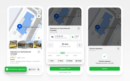
The Yandex team has announced a significant update to its mapping service. Now, Yandex Maps offers a unique, highly detailed map for drivers in Turkey, making it the first such solution among global navigation systems.

The new map displays the streets of Istanbul with maximum accuracy. It includes lane markings, pedestrian crossings, safety islands, and other important elements that will help drivers navigate complex intersections more easily.
As part of the update, over 2250 kilometers of roads in Turkey's largest city have been digitized. Detailed markings are available on the main streets of central Istanbul and on routes to two key airports: Istanbul (IST) and Sabiha Gökçen (SAW).
The update can be used in the Yandex Maps and Navigator applications. To see the new map, simply build a route and press the "Go" button.
The creation of a map with detailed markings was made possible thanks to the technology of reprojecting panoramas. The tool overlays panoramas on satellite images, taking perspective into account.
Read more on the topic:
Routes without stairs are now shown in Yandex Maps
Panoramas for over 400 settlements have appeared in Yandex Maps
A trip via Yandex Taxi in Turkey was successfully paid for with a Mir card