The team of the popular reference and mapping service 2GIS has introduced a new feature - "Joint Trips." Now, all participants of a trip will be able to see each other on the map for a limited time. After the trip is completed, information about the participants will disappear automatically.

This feature is especially useful for short trips, walks with friends, or business meetings when you need to quickly coordinate plans but don't want to add all participants as friends.
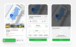
How to connect a joint trip in 2GIS:
- Open the application and go to the "Friends on the map" section.
- Click the "GO!" button and create an event - specify the name, description, and choose the duration of the trip: 24 hours, 3, 7, or 14 days.
- Send the participation link to friends in any messenger.
- All trip participants will be displayed on the map for the selected time, even if they are not your friends in 2GIS.
You can always hide your location or end the trip early. The "Joint Trips" feature is provided free of charge to all users of the 2GIS mobile application. To take advantage of this opportunity, update the application to the latest version and register in the "Friends on the map" system.
Read materials on the topic:
2GIS has ultra-detailed roads for cars with Apple CarPlay and Android Auto
2GIS has launched the "Lens" service for automatic shooting and analysis of urban areas
Pay for travel in a couple of clicks: 2GIS has integrated ticket purchase into its application
2GIS has ultra-detailed roads for cars with Apple CarPlay and Android Auto
2GIS service has launched the projection of routes onto the windshield of a car