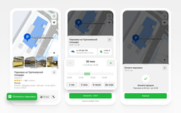
The 2GIS team has introduced a map update for car media systems that support Apple CarPlay and Android Auto. Now, users can enjoy improved road displays with up-to-date data on lane widths, markings, pedestrian crossings, traffic lights, parking pockets, and three-dimensional interchanges. These innovations are available not only in the 2GIS mobile application, but also on the screens of car multimedia systems.

The updated maps include super-detailed data for cities such as Moscow, St. Petersburg, Novosibirsk, Yekaterinburg, Kazan, Nizhny Novgorod, Krasnoyarsk, Chelyabinsk, Samara, Ufa, Krasnodar, Omsk, Perm, Rostov-on-Don, Voronezh, Volgograd, Sochi, Irkutsk, Tyumen, Murmansk, Kemerovo, Leninsk-Kuznetsky, Petrozavodsk, and Gorno-Altaysk.
Now, the maps display not only lane markings, but also pedestrian crossings, traffic lights, three-dimensional interchanges, exits, traffic islands, and speed camera zones. The supports on multi-level roads have also been updated, and tunnel entrances are presented in realistic 3D, making it easier to navigate the route.
The new update is available in the latest versions of the 2GIS app for iOS and Android, which can be downloaded from the AppStore and Google Play.
Read materials on the topic:
2GIS has started building routes inside buildings and shopping centers
Now on home

Start of deliveries scheduled for 2027

Over 51,000 new motorcycles were sold in Russia in 2025

The car will take at least a year to assemble

The application's audience has reached 20 million users

The model will be included in the list of cars for taxis, price - from 2.25 million rubles
All parking lots of the "Administrator of the Moscow Parking Space" are connected to the service

The cars will be supplied to the Moscow Transport Service Directorate
Deliveries to India may begin in 2028

The technology provides automated search for all types of defects in power units

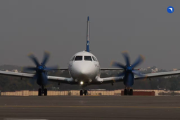
The plane flew 500 km, accelerating to 425 km/h

The plant stated that the information about the termination of purchases for models 6 and 8 is not true
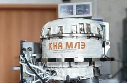
Scientists are using the "Ekran-M" installation